|
||||
|


|
|
|
|
|
Palaeogeography of an Ubaid Archaeological Site, Saudi ArabiaArabian
archaeology and
epigraphy H.
A. McCLURE AND N. Y. AL-SHAIKH
Palaeogeographic analysis and radiocarbon dating
indicate that sometime in the second half of the fifth millennium BC a sea-level
rise occurred along the coast of the western side of the Arabian (Persian) Gulf.
Cultural remains of the ‘Ubaid archaeological period are intimately associated
with the event and the palaeogeographic environment that accompanied it. The
sea-level rise appears to have had a catastrophic effect on habitation sites. Within Holocene time, in addition to the availability
of resources for exploitation, other important natural constraints that may be
assumed to have controlled ancient human populations living along the western
coast of the Arabian (Persian) Gulf are accessibility and quality of
ground-water, local spring discharge, and sea-level fluctuation.
Sea-level fluctuation can obviously affect littoral populations dependent
on shoreline activities such as fishing and maritime trade. Inundation of habitation or activity sites in the case
of sea-level rise can obliterate such populations or force movement inward. Shoreline may be especially at risk even in the case of
minor sea level fluctuation.
This paper documents the palaeogeographic environment of the time and
effect of a minor sea-level rise on what is figured to have been a prehistoric
population of ‘Ubaid cultural period living
along the western coast of the Arabian Gulf sometime in the latter half of the
fifth millennium BC (1).
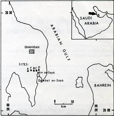
The area studied is located about 10 km south of Dhahran, Saudi Arabia,
on the south side of the Dammam structural dome. A group of five more or less
separate but apparently related archaeological sites occur in the area, aligned
in a west to east strike on a traverse of about 6 km width along an approximate
latitude of 26 13
N. For the purposes of this paper, the sites are designated, west to
east, A, F, B, C, and D. The easternmost site, D, is considered to have been a
principal
Fig. 1. Index map, showing locations of sites mentioned in text. occupation site. It is situated north, slightly east,
of ‘Ain as-Sayh, a spring located at the head of the embayment complex of
sites are indicated on USGS Map I-208A (2). The group of sites is referred to in
this paper as the “Ain as-Sayh complex”. Fig. 1 is a location map. Palaeogeography The sites presently occupy a series of shallow
depressions and indentations cut by natural erosion of wind deflation and recent
human industrial activity into sandy silt flats and low dunes a few kilometers
inland from the present shoreline at an elevation of about
1.2 m above high-water. The sites are bordered inland by a discontinuous line of
low rolling dunes partly stabilized by scrub palm clusters and sparse grass
cover. Further north, rock outcrops of the Dammam structural dome comprise the
main landscape feature.
The present silt and sand flats on which the sites are situated represent
fossil remnants of a former higher sea level at a time when sheltered,
shallow-water lagoons or inlets and tidal flats were the main features of the
area. Diagnostic sub-fossil marine shell species constituting the dominant
element of the biotope occupying this former marine environment, some still
occurring in situ in growth position, include: Circe Arabica
(common), Sanguinolaria ?cumingiana (common), Cerithidea cingulata
(common), Pinctada radiate (rare), serpulids, and other rarer small
gastropods. The barnacle, Balanus amphitrite, occurs along what would
have been the high-water line where a splash zone was present adjacent to land.
An open beach line with abundant whole and comminuted shells of diverse species
and derivation from a mixture of deeper water biotopes was not present. The sand containing the shells is only a few
centimeters thick, indicating that deposition was of short duration. It overlies
biologically and culturally sterile sand.
In addition to occupying a significant niche in the fossil biotope by
serving to indicate the former high-tide line, the other significance of the
barnacles is that they adhere to the objects they serve to date. In the
particular case at hand, as will be seen, they encrust cultural remains
considered to be of the ‘Ubaid archaeological period and, in addition to
providing an absolute time framework, also furnish an important clue in
decipherment of natural events that drastically affected human populations
living in the area (3).
The area of ‘Ain as-Sayh, the spring, would have been a marsh, as it is
today, fringed with Typha and Phragmites reeds.
The ‘Ubaid populations lived along the edge of a palaeoenvironment of
lagoons, tidal flats, and inlets (at the time occurring a little further
seaward), evidently exploiting marine life (fish and shellfish) and boating and
maritime facilities. They were already precariously perched only a bit above the
high-tide line. This environment was then displaced further inland by the
sea-level rise, resulting in inundation of habitation and activity sites. The
high sea-level need not have lasted very long, perhaps as only a few years. Chronology McClure and Vita-Finzi established a shoreline
chronology based on radiocarbon analyses to evaluate a neo-tectonic deformation
along the littoral of the western side of the Arabian Gulf (4). They dated
Holocene palaeo-shorelines over a distance of 350 km from the Lawdhan Peninsula
in the north to the base of the Qatar Peninsula in the south. Dates on a similar
shoreline of Holocene age along the coast of the United Arab Emirates (Trucial
Coast) had already been reported (5). The chronology established by McClure and
Vita-Vinzi was refined by additional radiocarbon and palaeogeographical analyses
by the same two authors (6). In this second study, first-order dating (7) and
additional conventional radiocarbon dating were applied to more mollusks and
barnacles associated with the same section of palaeo-shoreline originally
reported near Dhahran, but extended on a traverse eastward to Site D. The close
agreement obtained between ages for the barnacle, Balanus amphitrite,
adhering to cultural remains of the ‘Ubaid archaeological period, Circe
Arabica in growth position, and Cerithidea cingulata ,
showed that a wide range of shell material and species could be used for
reconstructing the nature and age of the former shoreline and high-tide line.
Ages obtained on a number of conventional and first-order analyses were in very
close agreement, within limits of the radiocarbon dating technique. At Site F,
ages in years BC (uncalibrated conventional) are: Circe Arabica 4320 +
80; Cerithidea cingulata 4380 + 70; and Balanus amphitrite
4430 + 90. All three ages may be taken, within limits, as representing
the same event, the sea-level rise, accompanied by changes in geography and
environments that affected sites documented in this paper (8). The archaeological sites
(described west to east) Site A, a minor site from the standpoint of cultural remains
(9), yielded a few fragments of hard, gray, lime plaster, impressed with a
pattern of twisted and bound reeds on one side, smooth, pink washed, and
barnacle encrusted on the other. The plaster fragments are considered to
represent remains of some kind of building. Similar remains from ‘Ubaid
excavations in southern Mesopotamia were called “huts” (10). It is important
to note that the barnacles encrust pieces that are found presently smooth face
down in the sand. Considering the living habits of barnacles – they do not
burrow, for one thing – the walls of the “huts” from which the plaster
pieces derive can be assumed to have been standing at the time of encrustation.
Barnacles encrusting outside surfaces (i.e., where the bound reeding is assumed
to have been exposed) would have disassociated quickly due to rapid decay of the
reeding. Lots of barnacles lying around loose may be the product of this
process. As such flimsily constructed structures can hardly be expected to have
stood long after abandonment due to any other reason, it is reasonable to assume
that abandonment was due to events of which the barnacle encrustation was a
by-product, i.e., sea-level rise, rapid marine inundation, and presence within a
high-tide zone.
The reeding of which the “hut” walls were constructed very likely was
derived from twisted leaves and bound stems of the common Middle Eastern
brackish water reed, Phragmites communis (11).
Several pieces of light red, coarse pottery were present at the site.
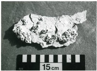
Only one “hut” seemed to be represented. At Site F, a cluster of 5 or 6 more or less distinct sand
mounds, each about 0.5 m high and about 1.5 m in diameter, contains abundant
large and small fragments of the same kind of plaster that is present at Site A.
A number of the fragments, as at Site
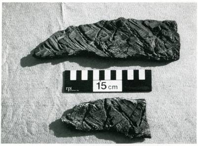
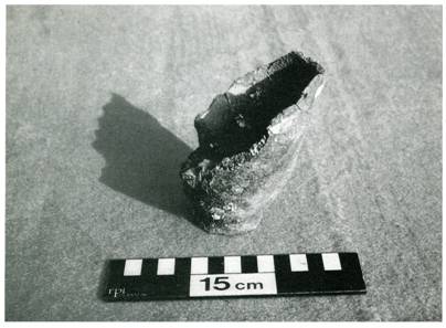
Fig. 2. Smooth, pink-washed, barnacle-encrusted inside surface of a piece of
reed-impressed lime plaster. Site F. A, retain a pink wash on the smooth side, in addition
to being encrusted with barnacles. Pieces of the plaster are illustrated in Fig.
2 and 3. One pieces of painted pottery was found at the site, along with several
pieces of plain, coarse, red pottery. A few flint chips and one piece of tile
flint were present. No other
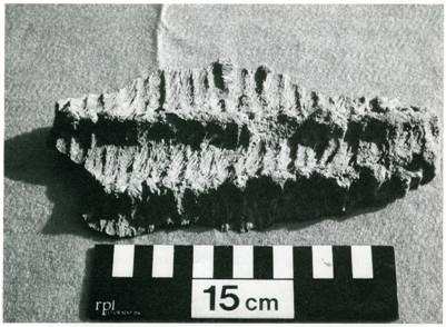
Fig. 3. Piece of lime plaster showing reed-impressed outer surface. Site F. occupational debris was obvious, though proper
archaeological examination might reveal such. The “hut” appear not to have
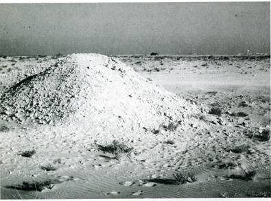
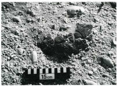
been utilized very long. Fig. 4 depicts several of the sand mounds with
fragments of plaster weathering out.
Fig. 4. Sand mound with pieces of reed-impressed lime plaster weathering out.
Site F. (15 cm scale in lower left).
Some stratification is evident at the site. A thin, lightly calcreted,
soft sandstone crust bearing possible root or stem casts caps some of the
remains, in turn overlain by present mobile, sterile dune sand. Site
F occurs at the edge of an artificial hollow where bulldozers have removed
material for construction purposes and recent wind deflation has been active.
The remains of two other “hut”, indicated by pieces of plaster scree and
barnacles weathering from the dune sand, occur at the south side of the hollow.
Other such remains may be present in immediate nearby areas underneath
undisturbed dune sand.
The relationship of the “hut” –bearing sites of A and F to other
sites of the ‘Ain as-Sayh complex, especially the (assumed) main occupation
site of D, discussed below, may be subject to future archaeological
interpretation, but the two sites, probably task oriented, were apparently
co-eval with the other sites, all of which display evidence of barnacle
encrustation. At
Site B, small pieces of reed-impressed plaster and a number of pieces of
painted pottery considered to be of ‘Ubaid typology occur in a debris pile
dredged and scraped out of a thin
Fig. 5. Debris pile, about 2m high, which yielded painted pottery sherds and lime
plaster fragments. Exposed crust (white horizontal patch) in upper right
background. Site B. crust and overlying dune sand by bulldozer activity
(Fig.5). One piece of painted pottery, however, the cross-hatch patterned one of
Fig. 6, occurred still embedded in a patch of undisturbed crust. One piece of
the pottery had small barnacles encrusted on it, barnacles being otherwise very
rare at the site. A few flint chips and one piece of tile flint were found.
A substantial part of a large building of rough faroosh blocks (12),
Plastered on the inside, with a height of more than a meter, occurs at a higher
elevation on a small sand hillock at the site. It seems likely to be of later
date, but serves to mark Site B. The
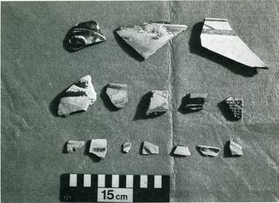
Fig. 6. Patterned and painted sherds of ‘Ubaid typology. Cross-hatched sherds
of far middle right occurred in situ in the crust. Site B. site, unlike the others of the complex, is otherwise
unstructured, significant mostly for the painted pottery that occurs there. The pottery sherds and plaster pieces have a re-worked
aspect. (Could Site B be an earlier site abandoned for another reason, then
reworked and barnacle encrusted by the sea-level rise documented in this paper
?) Fig. 6. illustrates some of the sherds (13).
More significant structured remains may lurk underneath overlying sand
terrain surrounding the dredged hollow. As at Site D, described below, lagoon
shells do not occur in the immediate vicinity. The barnacles, though few and
small, indicate that, like Site D, it was nevertheless within the high-tide
zone, perhaps elevated a bit above what became lagoon level when the sea-level
rise occurred. Site C can be characterized mainly by the occurrence of
moderately coarse, red and pink, large fragments of round-bottomed pottery, some
of which are bitumen coated and barnacle encrusted. The bitumen is the most
interesting and probably most significant item at the site. It occurs as a thick
coating, which may be on the order of half a centimeter thick or more, running
down the sides and covering the bottoms of some of the vessels (Fig. 7 and 8).
Bitumen was evidently the bulk product contained and processed in the pottery
and not a simple coating to render it impervious.
Scattered gray low humps of sand containing blackened and feature of the
area.
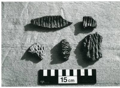
Another interesting item at the site comprises flat bitumen
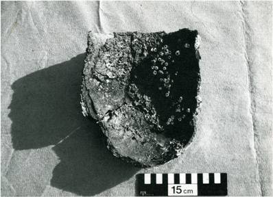
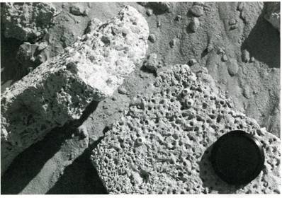
Fig. 7. Inside surface of a large fragment of a round-bottomed, bitumen-coated
and barnacle encrusted pot. Site C.
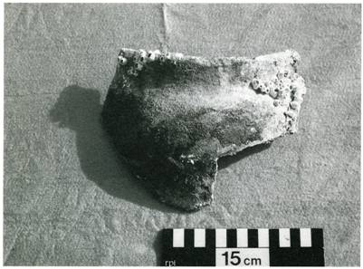
Fig. 8. Outside barnacle-encrusted surface of part of a pot similar to that of
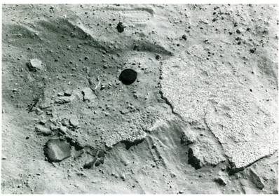
Fig. 7. Site C. fragments about a centimeter or less thick, impressed
with a woven reed pattern, the largest illustrated in Fig. 9. The fabric
represented suggests usage of split lengths of Typha stems (14). The
fragments may have been parts of a bitumen substratum on which woven reed
matting was placed. Another piece of reed-impressed bitumen displays a fabric
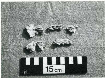
indicating bound reeding laced with fine, twisted, double-stranded threading. Still other fragments occurring as
sandstone casts seem to represent coarsely woven cloth. Bitumen fragments and
sandstone casts
Fig. 9. Large bitumen fragments impressed with a woven reed pattern. The two
pieces fit together at the right ends. Site C.
Fig. 10. Bitumen fragments impressed with various fabrics. Site C. displaying fabric impressions are illustrated in Fig.10
and 11.
A number of pieces and fragments of faroosh blocks, some smooth on one
side, is associated with the humps of sand mentioned enough to have constituted
flooring or building remains, and may have been simply used as work bases of
some kind or in hearths for working with the bitumen.
Fig. 11. Impressions of coarse fabric preserved in sandstone casts. Site C.
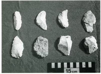
Fig. 12. Flint pieces. Upper right-hand 3 specimens appear to be of scraper
typology. Site C.
Some pieces of flint occur at the site, several possibly retouched for
use as scrapers (Fig. 12). They resemble flakes that might have been derived
from deposits of nodular or bedded flint to be found in Eocene limestone
outcrops riming flanks of Dammam dome.
In addition to the red and
pink pottery at the site, a substantial part of a small, light-red, vase-shaped
pot with narrow base and barnacle encrustation was found (Fig. 13). Several of
what appear to be the same type occurred at the main site of D, discussed blow.
Fig. 13. Large fragment of a small, light-red, vase-shaped, narrow-based. Site D.
Fig. 14. Surface of Site C showing abundant palaeo-lagoon shells and large piece
of blackened and baked pottery and weathered bitumen.
The barnacle encrustation serves to indicate it probably not of later
intrusion (but see reference 15). One piece of painted pottery was found at the
site.
It is too tempting not to speculate the Site C may have been used to
process bitumen for caulking or otherwise working with reed boats. The bitumen fragments impressed with woven reed pattern may
indicate matting used for comfort or linings in boat bottoms. The weave pattern
and fabric as well as the flat shape are suggestive of matting, not basketry
work. Some of the other impressed bitumen fragments at the site may indicate
parts or accessories of reed boats.
No natural bitumen seepage sites are known to exist on the Arabian
Peninsula, Bahrain, or Kuwait that were capable of producing usable bulk
bitumen, the nearest practical source being the Hit area of southern Iraq on the
Euphrates (16).
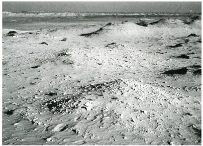
The area of Site C is now a silty sand flat, presently profusely covered
with the palaeo-lagoon shells described above (Fig. 14). The cultural remains
described here are inconspicuous, requiring careful scrutiny, study and
interpretation. Site D appears to have been a main habitation site. It has
been exposed in an area presently characterized by low dunes, sand humps, scrub
palm clusters, and evidence of much recent industrial disturbance. It was
formerly covered with Aeolian sand and later occupation debris of abundant
Islamic and other Pre-Islamic, post ‘Ubaid periods (17). Bulldozer operations
of about 20 years ago exposed the site. Lithologically, the occupation level
comprises an indurated, hard, sandy crust roughly 15 cm thick, in which are
imbedded cultural remains.
Fig. 15. Faroosh (walling ?) blocks with barnacle encrustation. Site D.
Fig. 16. Crust with faroosh flooring ? stones and pot sherds embedded. Site D.
(Lens cap for scale).
Fig. 17. Vertically set rows of faroosh slabs possibly comprising floor
foundation. Patches at lower right hand corner and at upper left. Considerably
more might be revealed under the loose sand scree presently covering the area.
Site D. (Paint brush about 9 cm width for scale). The crust
is probably a product of cementation due to sea-water inundation at high-tide,
plus perhaps some compaction due to former human occupation activity. It is
underlain by unconsolidated, culturally and biologically sterile fine sand and
silt, evidently representing the initial level and substratum on which the
original population set up habitation and lived until catastrophic sea-level
rise. Much of the crust is now covered by a light, thin scree of loose sand
blown in after originally bulldozer exhumation and still mobile over the area.
Large patches are prominently exposed, though, and the rest is easily uncovered
with brush or broom.
Most important at the site are building remains, exposed by the bulldozer
activity. Fig. 15 illustrates faroosh blocks (walling ?) with barnacle
encrustation. Fig. 16 illustrates some of the crust with slabs of faroosh
flooring ? stones and pot sherds imbedded. Nearby are tow patches several square
meters in size (or very possibly more when properly exposed) of what appears to
have been a floor foundation composed of uniformly thin
Fig. 18. Close-up of vertical foundation slabbing (at middle right), with partial
covering of flooring slabs apparently in situ in foreground. Site D. (15
cm scale in middle right).
Fig. 19. Mosaic of pottery sherds (all of same pot) imbedded in crust of Site D). faroosh slabs vertically set, firmly and evenly spaced,
in the sand substratum (Fig. 17 and 18). The supposed flooring, wall portions,
and foundation stones all occur close together, suggesting the base of a single,
substantial building of careful workmanship (18).
Light brown or red pottery sherds are frequent in the crust. Painted
sherds are rare, but much of a large, globular, round-bottomed, cream-coloured
pot, painted with closely spaced diagonal stripes and horizontal banding, can be
reconstructed from pieces apparently randomly but deliberately laid after
breakage in a sort of mosaic, possibly to form a working base of some kind (Fig.
19 and 20). Several specimens of a particular kind of small, brown vase or cup,
very much like the one of Site C (Fig. 13), were noted, in addition to some
short, brown, straight pot spouts.
Fig. 20. Close-up of imbedded pottery sherds of Fig. 19. Site D.
Though remains of later cultural period along with ‘Ubaid mixed in as
part of the bulldozer disturbance can be found in humps of disturbed sand and
debris, the crust is important as containing in situ remains.
No reed-impressed plaster fragments were noted at the site, the faroosh
blocks being the only indication of building, highly important as they are.
Absence of the plaster, so ubiquitous at sites elsewhere, must have a
significance, assuming true contemporaniety of the sites. A possible clue to how
‘Ubaid communities were structured may be provided.
Only a few small pieces of reed-impressed bitumen occur. Flint tools of
definite typology and arrow points, so prominent on other Arabian ‘Ubaid
sites, appear conspicuously absent, though some flint chips and flakes occur,
similar to those of Site C.
Other occupation items, not investigated much but readily observable in
the crust, in addition to the pottery sherds and faroosh blocks, include a
string of beads, fragments of several small alabaster jars, copper tools
(several awls and razors ?), pounding stones, spindle whorls ?, perforated
discs, common fish bones and spines, articulated vertebrae, bovid? Teeth, tusks
of some sort, and mollusk shell fragments. A number of the shell fragments
scattered in the crust are of Pinctada radiata and a large muricid
gastropod, probably food sources (19).
No lagoon shells occur in situ at the site, possibly indicating it
was originally at a slightly higher elevation than the other sites (with the
possible exception of Site B), not surprising considering it appears to have
been the main habitation of the complex. The splash zone of high-tide clearly
occurred her, though, evidence being the barnacle encrustation on the building
blocks.
The fresh-water supply to support local populations and provide reeding
surely derived from ‘Ain as-Sayh, located to the immediate south of the site.
It is still flowing, but is heavily sanded over and now discharges as seepage
into the Gulf and adjacent sabkhas.
Site D is presently located at the side of a major carriageway and is
subjected to heavy local recreational activity. It is consequently rapidly
deteriorating as an archaeological site. Conclusions Anything but tentative conclusions at this stage of the
study of the ‘Ain as-Sayh sites as well as other ‘Ubaid sites in Arabia
would be premature. The ‘Ain as-Sayh complex of sites clearly should be
subjected to proper archaeological investigation, detailed, and interpretation
in the future. It therefore seems best as final conclusion to this paper simply
to pose some questions that future studies and analyses may elucidate. 1.
Can the usage of bulk bitumen at Site C be taken as evidence for a
maritime connection with southern Mesopotamia during ‘Ubaid times? 2.
What role did the reed-impressed plaster “huts” play in ‘Ubaid
cultural activity. 3.
Can Site D be taken as evidence for truly permanent habitation, perhaps
the only such ‘Ubaid site known along the Arabian coast ? 4.
Why do sites such as ad-Dossariyah contain much abundance of ‘Ubaid
painted pottery and the ‘Ain as-Sayh sites so relatively little ? 5.
Why are flint tools of definite typology such as tile flint knives and
scrapers and bifacial arrow points as found at other ‘Ubaid sites not
prominent at the complex ? 6.
Does the complex represent a one-time attempt, comparatively brief and
abortive, to occupy and exploit this part of the Arabian Gulf coast ? 7.
What was the relation of the complex of sites to other known sites of the
eastern part of the Arabian Peninsula ? 8.
How do pottery typologies and other features compare with other Saudi
sites and Mesopotamian, Qatar, Oman and Bahrain sites ? 9.
Masry indicates with an “X” a site characterized by flint tools to
the east of ‘Ain as-Sayh and east of Site D, approximately between ‘Ain
as-Sayh and the present coast (20). This was assumed to be an ‘Ubaid site
because of the presence of abundant tile flint tools and arrow points, a common
feature of other Saudi ‘Ubaid sites. No other clearly characteristic ‘Ubaid
remains apparently occurred at the site. Is this previously reported site part
of the complex further to the west, perhaps in some way another task-oriented
site ? 10.Can
the complex of sites, possibly including the tile flint site of 9 above and
possibly excluding Site B (as perhaps older), be taken to indicate a single
structured ‘Ubaid community ? References 1.
Enough is known about ‘Ubaid archaeological remains to separate them
out from other bodies of remains in time and space and to ascribe them to a
particular group of people. In the sense of a population group being defined by
such remains where cultural attributes can be implied, it seems acceptable to
use the term “’Ubaid culture”. The date is based on uncalibrated
conventional radiocarbon analysis. Calibration indicates an earlier period, the
latter half of the sixth millennium-see reference 8 below. 2.
Steineke M, Harris TF, Parsons KR & Elberg EL Jr. Geologic map of
the Western Persian Gulf Quadrangle, Kingdom of Saudi Arabia. Washington,
DC,: Miscel. Geol. Invest. Map I-208A, U S Geol. Surv., 1958. 3.
Balanus amphitrite occurs sporadically along the present open shoreline at the high-water
level where beachrock patches or debris dumped at the water’s edge afford a
solid attachment not otherwise available on the smooth, sandy, shallow-water
substratum. Barnacles can become established in a very short time- a month or
so; lagoon mollusks such as the assemblage described above may require only a
few seasons. 4.
McClure H & Vita-Finzi C. Holocene shorelines and tectonic movements
in eastern Saudi Arabia . Tectonophysics: 85: 1982: 37-43. 5.
Taylor JCM & Illing LV. Holocene intertidal calcium carbonate
cementation in Qatar, Persian Gulf. Sedimentology 12: 1969: 29-107. 6.
Vita-Finzi C & McClure HA. High resolution C-14 dating of an uplifted
Holocene shoreline in eastern Saudi Arabia. Tectonophysics 194: 1991:
197-201. 7.
Vita-Finzi C. First order C-14 dating of Holocene mollusks. Earth and
Planetary Science Letters 65: 1983: 389-392. 8.
Calibrated true calendric date ranges, calculated from tables of klein et
al. (klein J, Lerman J, Damon P & Ralph E. Calibration of radiocarbon dates:
tables based on the concensus data of the Workshop on Calibrating the Radiocarbon
Time Scales. Radiocarbon 24: 1982: 103-150, are: for the uncalibrated
date of 4320 BC, 5475-4965 BC ; for the date of 4380 BC, 5520-5065 BC; for the
4430 BC date, 5590-5070 BC. The ranges are broad, reflecting the present state
of the art, but certainty within the ranges is considered to be on the order of
95%. 9.
Called site 4 in McClure & Vita-Finzi, Holocene shorelines. 10.
Woolley CL. Ur excavations, IV. Philadelphia: Univ. Museum, 1955.
The Mesopotamian plaster is apparently of mud, a product readily available in
the area. Suitable mud would have been less available at the ‘Ain as-Sayh
sites, but marine shells for lime plaster would have been plentiful. Woolley
presents a cross-section drawing of a piece of the Ur plaster (p. 7, Fig. 2). 11.
Barnacle-encrusted plaster is also reported at ad-Dossriyah, an ‘Ubaid
site further to the north. (Bibby TG. Preliminary survey in Eastern Arabia,
1968. Aarhus: JASP, XII: 1973; Burkholder G. ‘Ubaid sites and pottery in Saudi
Arabia. Archaeology 25: 1972: 264-269). 12.
Faroosh – a well-cemented beachrock, composed of a coquina of small,
whole and fragmented shells. Used locally as building stone until recently. 13.
The sherds are illustrated, described in detail and typologically
analyzed in a separate paper in this volume by B. Hermansen. 14.
Typha
would be more appropriate for matting. Not being a grass, as Phragmites,
its stems do not have nodes to hinder lengthwise splitting. 15.
Hermansen, this volume, considers this piece of pottery (his type 10) to
be typologically within the Jamdat Nasr-ED chronological range. There is thus a
discrepancy between the absolute chronological scheme based on shell dating and
contexts and Hermansen’s typological chronology. This is obviously a problem
to be resolved in the future when more detailed analysis of the sites can be
undertaken. 16.
Zarins J, Mughannum AS & Kamal M. Excavations at Dhahran South. Atlal
8: 1984: 36. 17.
A cylinder seal found at the site has been tentatively identified as of
Warka style. Hermansen, this volume, documents later post-‘Ubaid evidence. 18.
Possibly non-secular. It is tempting to wonder if the remains of a temple
may be represented. 19.
Pinctada margaritifera, the larger, deeper-water, “Pearl Oyster” of the
Gulf (not really an Oyster), does not seem to be represented. There is no
obvious indication that pearling was a part of the activity of the population. 20.
Masry AH. Prehistory in Northeast Arabia: the problem of interregional
interaction. Miami: Field Research Projects: 1974: 79, map 7. Addresses: H. A. McClure Natural History Museum Cromwell Road London SW7 5BD UK N.Y.AL-SHAIKH BBC Brown Boveri Dammam, Saudi Arabia New addresses: Nabiel Y. al Shaikh Dammam Regional Museum Gen.
Directorate of Education in the Eastern Province Dammam 31158 Saudi Arabia
Telephone: 00 9663 8266056 E-mail: nabielalshaikh@yahoo.com
|
|
|
Send E-mail to
TSN@The-Saudi.Net with questions or
comments about The Saudi Network.
We are Looking for Business Sponsorship or Marketing Partnership |